PROJECTS

Bottom Brook

Overview

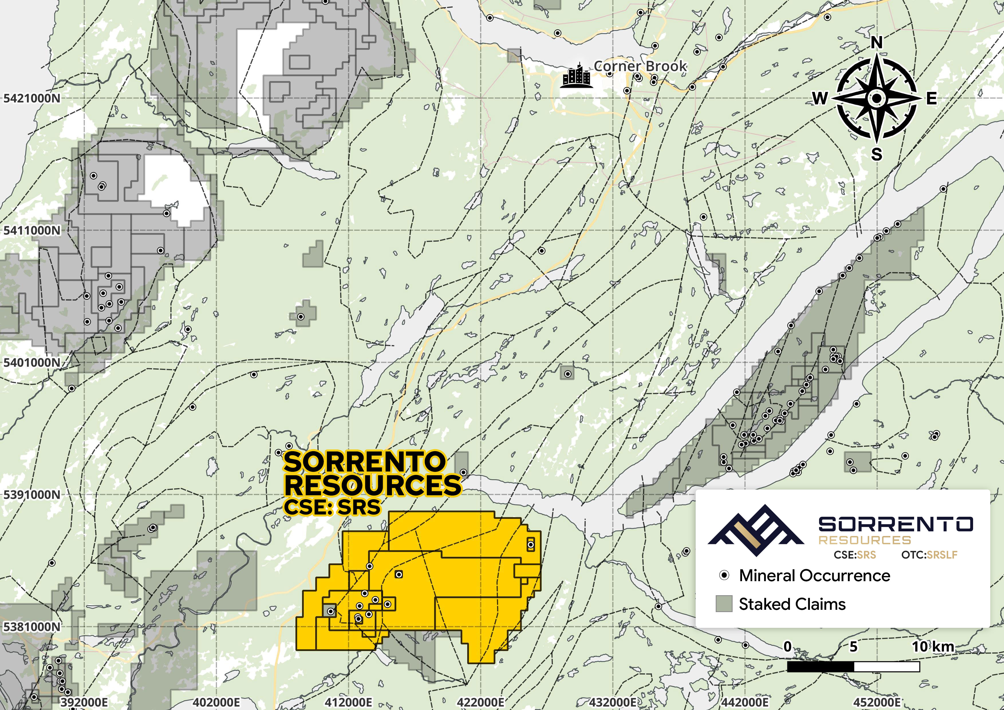
The Bottom Brook project consists of 16 mineral licences totaling ~15,150ha, located approx. 40km south of port community of Corner Brook, Newfoundland. The project is accessible through a network of secondary roads, immediately adjacent to the Trans-Canada Highway.

The project has had 27 drill holes to date, with significant total rare earth oxide intercepts including:

11.02% over 1.05m (2007)
8.19% over 2.00m (2007)
15% over 0.5m (2008)

Project History

1980-1982
  • Shell identifies U-bearing Boulders
2006-2007
  • Ucore discovers bedrock U-mineralization (Bottom Brook A and U2 Showing – U2 not within Bottom Brook Claims)
  • Radiometric/Magnetic Survey
  • Drills 3 holes into Bottom Brook A, highlights including:
    • 4.37% Total Rare Earth Element Oxides (TREO) over 5.03 m
    • 11.02% over 1.05 m
    • 4.47% over 5.64 m with 8.19% TREO over 2m
2008
  • Monroe Minerals drills an additional 9 holes at Bottom Brook A showing featuring a highlight intercept of 15% TREO over 0.5 m and 1.2% over 15.3 m
2010
  • Kirrin Resources drills 4 holes
2023
  • York Harbour acquires project and completes trenching, channel sampling, SEM-MLA, and a 1,701m drill program over 10 holes

Geology

Bottom Brook is located within the Laurentian Margin, within the southwestern edge of Mesoproterozoic and Neoproterozoic Humber Zone in the Steel Mountain Subzone. The property lies within the northeastern portion of the Steel Mountain Subzone, characterized by late Proterozoic metamorphic rocks intruded by later Proterozoic peralkaline leucogranites from the Hare Hill granite complex.

Steel Mountain Subzone

  • Disappointment Hill Complex: pyroxene granulite gneisses
  • Steel Mountain Complex foliated amphibolite, norite, gabbro and granitoid gneiss

Hare Hill Granite Complex

  • Host mineralization contained within Hare Hill peralkaline leucogranite complex
  • Mineralization could be in consumed sedimentary gneiss or lies within a mafic phase of the complex
  • Mineralization is dominated by REE-rich Monazite, with lesser Zircon, allanite, apatite and trace Ce-carbonates

Deposit Model

Rare-earth mineralization at Bottom Brook is characterized by monazite-enriched horizons. The distribution of Rare Earth Oxides in high grade core sample 519139 (Penney and Reid, 2009) is almost identical to the giant carbonatite Bayan Obo deposit – a major REE reserve estimated at more than 57.4 million metric tons grading at 6% and accounts for nearly half of global REE production (Fan, 2016).

Bottom Brook REE mineralization has also been compared to the Steenkampskraal monazite deposit in South Africa by Dr. Derek Wilton in 2024, which is one of the highest-grade REE deposit globally with a current mineral resource estimate of 665,000 tonnes at an average grade of 14.5% TREO.

Mineralization exhibits considerable Light Rare Earth Element (LREE) enrichment (10,000 – 100,000x chondrite) compared to heavy rare earth elements (HREE; 100 – 1,000x chondrite). The LREE constitute between 95 and 96% of the total REE content of samples with > 1% TREO.

Geophysics

Airborne Equivalent Thorium Survey

  • Airborne Equivalent Thorium Survey on the Bottom Brook Property (map compiled by Oneschuk and Kilfoil, 2021)
  • High Th anomalies are associated with the Hare Hill granite complex

Total Field Magnetics

  • Total Field Magnetics Map of the Bottom Brook Property (derived from data in Fitzgerald and Smith, 2007)
  • Anomalous Mag intensities correlate with the Hare Hill granite complex and 1500 Ma granulites

SEM-MLA

  • SEM-MLA (scanning electron microscope – mineral liberation analysis) was carried out in 2023 by Terra Rosetta Inc. (Dr. Derek Wilton) on several field samples
  • Best sample returned 35.98 area % total REE in thin section
  • Analysis determined that REE are hosted in monazite – a mineral amenable to well-established metallurgical processing methods
Sample Total REE Monazite
G435.9831.85
REE-118.8616.45
Q26.835.69
Q45.583.32
Q34.193.36
Q1(2)3.791.99
TR-43.521.24
Q12.191.23
TR-21.980.31
TR-31.820.32
TR-11.270.25
TR-50.620.08

2023 Work

Channel Sampling

York Harbour Metals collected a total of 17 channel samples varying from 0.2 to 1.5m in length for a total of 16.9m from two trenches, including highlights of:

  • Samples 116676-116678: 3m at 1.38% TREO (including 1m at 2.28% TREO)
  • Samples 116679-116682: 4m at 0.87% TREO
  • Sample 116686: 1.5m at 1.07% TREO

Drilling

2023 drilling by York Harbour Metals consisted of 1701m and 10 holes, testing results from REE channel sampling and historic graphite targets.

  • 0.6% TREO over 2.94m

Exploration Targets & Next Steps

Bottom Brook features several undeveloped targets identified by surface sampling:

Prospect 1

  • Outcrop of altered granite, w/rusty veins
  • Grab sample assayed 2.87% TREO
  • Approx. 1.75 km NE of the U3 Zone

Prospect 2

  • Rusty pegmatite vein in altered biotite-rich granite
  • Grab samples: 5.21% and 6.54% TREO
  • 875m northeast of U3 Zone

Prospect 3

  • East showing assayed 4.78% TREO
  • Hematite-rich granite with magnetite
  • West showing: 4.89% TREO

A two-phase program is proposed for Bottom Brook:

Phase 1

  • Airborne remote sensing survey
  • Soil sampling, boulder sampling, prospecting, and channel sampling
  • Whole rock geochemical and petrographical studies

Phase 2

  • 3,000m drill program on targets identified in phase 1

Join Our Mailing List

Sign up to receive updates on our latest news and events. Your email will never be shared or sold and you can opt out at any time.

No, I don't want to receive updates

Thank you for subscribing!

We'll send you updates on our latest news and events.

Close